Overview
The GIS module provides essential features for command and control systems to display information in a geospatial context (specifically, on a map).
Key Features
Map Rendering Interface
- The map rendering interface is designed to allow changing web renders (e.g. Mapbox vs CesiumJS) without having to rewrite all your code
- The default implementation we have and are supporting is CesiumJS, if you need to use a different renderer such as Mapbox, MapLibre, or ArcGIS Maps SDK for JavaScript, you will need to implement it yourself
Camera Bookmarks
- Save and delete camera position
- Fly to saved camera position
Geospatial Entity Rendering
- Custom styling for rendering entities on the map
- Fully custom styling via Svelte/HTML overlays for points
- Attribute-based styling for geometries
- Rendering entities on the map based at their geospatial coordinates
- Conditional rendering based on entity attributes
Operating Concept
The GIS comprises of the modlet, backend server, and database. The following diagram shows the GIS and its
dependencies. Note that in its current incarnation, the GIS is not involved in supplying map tiles. Its purview
is strictly for operational entities, and uses the RTUS to update these entities to the frontend live.
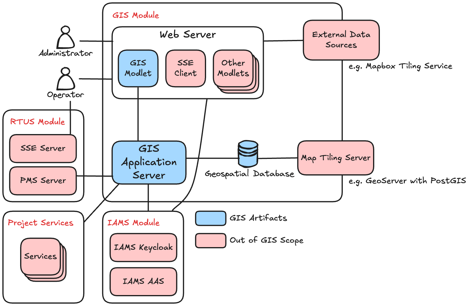
The operating concept of the GIS module is simple, the GIS is in-charge of storing entities that should be rendered
in a geospatial context - that is, a map.
Business entities should be dealt with in your own services, represented as "Project Services" in the component diagram
above. When a business entity needs to be displayed in a geospatial context, it should be added to the GIS as
geospatial entity (or geoentity for short) by calling the GIS's API's (on the GIS Application Server). Likewise, if it
should no longer be displayed on the map, it should be deleted by calling the GIS's API's. The updates to the frontend
are handled by the GIS module for you.
Swappable Rendering Engines
Effectively rendering a map is complex, so we use third-party engines to handle this. However, we understand that many
organizations might already have their own preferred map renderer, as enterprises often have partnerships with existing
map service providers. In order to support the capability of using other web map renderers, we've designed the GIS
around a layer of abstraction. Essentially, we provide an interface and a set of components to interact with our
"Gis Map". The "Gis Map" expects a renderer to handle the implementations for all the features required - this is in
the form of an "Engine Provider".
If any specific web (JavaScript) map rendering is required, it can be written as an engine provider to provide the "Gis Map" with the rendering capabilities needed.
The default web rendering engine we've chosen is CesiumJS, and our reference implementation can be found in the
CesiumMapEngineProvider Svelte component.